Life near the triple point
Dr Mark Claire of the Department of Earth and Environmental Sciences reflects on H2O in its three amazing forms, and its role in this week’s dramatic thunder and lightning.
Life on Earth is dominated by the chemical compound with formula H2O. This simple molecule sustains all life on Earth, defines the boundaries of planetary habitability and dominates both our climate and our weather.
“How inappropriate to call this planet Earth when it is quite clearly Ocean.”
– Arthur C Clarke
These phenomena – including this week’s spectacular thunder and lightning – are linked by the somewhat curious observation that the temperature and pressure at the surface of our blue planet spans the triple point of H2O; allowing ice, water, and water vapour to coexist.
Mighty glaciers calving into the ocean, vast rivers carving canyons with raging rapids, a lunchbreak spent on the Castle Sands daydreaming shapes in the clouds – all these iconic scenes from our planet exemplify humble H2O in its three amazing forms.
As Tuesday’s warm Sun heated up our waters to the point where some dared swim in the North Sea, the warmer surface air temperature allowed for some of the liquid H2O to evaporate and enter the gas phase. Left to its own devices, this warm air would have risen slowly through the atmosphere.
At a height of a few kilometres, where the temperature and pressure has dropped slightly, this gas phase H2O condenses back to a mixed water/gas phase of clouds and waits for the right opportunity to either fall as rain or evaporate again and eventually condense elsewhere.
This broad phenomenon is known as the “cold-trap” and keeps nearly all of our precious planetary water near the surface – without Earth’s surface temperature being near the triple point our precious water could be evaporated away and lost to interstellar space or all frozen on the surface as has occurred on our sister planets Venus and Mars. We live in a special place – on the phase diagram of water as well as the Universe.
This continual process of warm air rising and condensing was rapidly accelerated this week, as a blast of much colder air (itself driven by large scale evaporation of water from tropical regions transported and falling in temperate regions in broad planetary cells driving jet-stream circulations) settled in over our patch of Tuesday’s unusually warm and moist St Andrews air. The H2O condensed as usual, but the biting cold arctic air at the top of the clouds enabled direct passage to H2O’s icy phase.
Rather than raindrops falling through Wednesday morning’s clouds, there was hail. But this hail didn’t reach the ground as it might on a cool winter afternoon – Tuesday’s warm air at the cloud base prevented that, and enabled a wild cloudy ride spanning the triple point of H2O.
The normal turbulence of warm air rising, cooling and condensing in the cold-trap was dramatically enhanced by the rapid formation and falling of chunks of ice from the top of the clouds being flash heated at the cloud base and rising again.
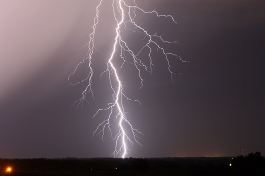
The falling of this hail through the turbulent dense clouds created friction which manifested as static electric charges, with the collisions imparting a negative charge to the falling hail. The warmer base of the cloud became negatively charged while the colder cloud tops gained a positive charge – and nature abhors a charge imbalance.
Eventually this charge imbalance is released in the merest fraction of a second, in a blinding flash of light which rapidly expands then contracts the surrounding air, forming rumbling pressure waves at a frequency which incite vibrations near the lower end of what our ears can register.
Thunder and lightning – brought to you this week by a planetary atmosphere that happens to be near the triple point of one of its main constituents.
Category Research