First detailed map of Scotland on display
The first map of Scotland detailing the Kingdom of the Scots is now on display at the University of St Andrews.
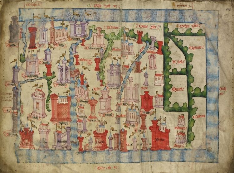
The University’s Wardlaw Museum hosts the fifteenth-century Hardyng Map of Scotland, on loan from the British Library as part of its Treasures on Tour programme, from Sunday 20 February to Sunday 3 July. The document is one of the earliest maps of Scotland.
Drawn in the 1400s, the map includes a colourful depiction of St Andrews, showing the now ruined St Rule’s Church. Visitors will be able to explore the Middle Ages in depth as the map will be displayed alongside another exhibition, Cult, Church, City, which brings together items from across the UK to tell the story of the town during this period.
It is thought the map was drawn from knowledge of Scotland gained by English chronicler John Hardyng on a secret mission to Scotland, on which he was sent to spy out the land by the English King Henry V. Hardyng included the map in his later chronicle, telling the history of England and its neighbours.
Principal and Vice-Chancellor of the University, Professor Sally Mapstone, is an expert in Medieval and Renaissance Scottish literature and, as a medievalist, is delighted to welcome Hardyng’s map to the University.
Professor Mapstone said: “Hardyng’s map provides important context to the dynamic relationship between Scotland and England throughout the ages. It has broad appeal not only to those studying here in St Andrews, but also to anyone interested in the ways in which Scotland’s geographical, political and cultural conditions have changed over centuries.
“Every map tells a story and I look forward to the discussion, debate and reflection that will be sparked at this critical juncture in Scotland’s future while the map is on display at the Wardlaw Museum.”
Dr Claire Breay, Head of Ancient, Medieval and Early Modern Manuscripts at the British Library, said: “We are thrilled to be loaning the Hardyng Map of Scotland to the Wardlaw Museum. It depicts many Scottish cities and towns and was used by Hardyng to accompany his historical chronicle.
“The British Library’s collections are for everyone and we hope this map, which is going on alongside other works connected with medieval St Andrews, will inspire new audiences, young and old. This loan is part of our Treasures on Tour programme and enables us to open up the Library’s collections to serve our communities better across the UK.”
Visitors to the Wardlaw Museum will have the chance to pit their wits against a fifteenth-century spy as part of an escape room experience accompanying the map, in which participants will be asked to crack clues that will help them capture John Hardyng on his Scottish reconnaissance mission, before he escapes to England.
Cult, Church, City: Medieval St Andrews is an exhibition created by Professor Michael Brown and Dr Bess Rhodes, world experts in the town during this period. On display will be items that have never before been seen together, including a brightly coloured bishop’s robe, on loan from the Victoria and Albert Museum in London.
Treasures on Tour: John Hardyng’s Map of Scotland and Cult, Church, City: Medieval St Andrews will be at the Wardlaw Museum from Sunday 20 February until Sunday 3 July 2022. Entry is free and a full programme of events will be offered. Details can be found on the University Museum web page.
John Hardyng’s Map of Scotland is part of the British Library’s Treasures on Tour programme and is generously supported by the Helen Hamlyn Trust.
Issued by the University of St Andrews Communications Office.