‘Super Henge’ Unveiled
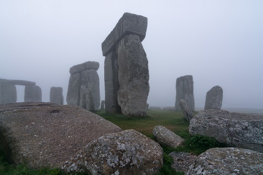
Scientists have unveiled a remarkable new picture of Stonehenge and its surrounding areas, including the remains of an even bigger ‘super henge’ nearby.
The mammoth project – the largest of its kind – reveals a host of previously unknown archaeological monuments, burial mounds and an immense ritual monument thought to be the biggest of its kind in the world.
Led by the University of Birmingham in conjunction with the Ludwig Boltzmann Institute for Archaeological Prospection and Virtual Archaeology, scientists behind the study say that it will transform our knowledge of this iconic landscape.
The digital mapping project involved scientists from across Europe and in Scotland, Dr Richard Bates of the University of St Andrews.
Dr Bates, an applied geophysicist at the Department of Earth and Environmental Sciences at St Andrews, was one of the project’s international partners. Dr Bates was called upon for his expertise in developing techniques to explore buried and drowned archaeological landscapes including the mysterious underwater world, Doggerland.
He said, “We can think of applied geophysics as the modern eyes and ears of science for discovering what is hidden beneath the Earth’s surface. The absolute latest in geophysical developments are being applied and showcased at Stonehenge and we can see the results of this in the new discoveries.
“What is really exciting is that these tools give us the opportunity to link actual find sites intimately to the landscapes that they were built in and used within.”
In the project, remote sensing techniques and geophysical surveys were used to discover hundreds of new features which now form part of the most detailed archaeological digital map of the Stonehenge landscape ever produced.
The startling results of the survey include 17 previously unknown ritual monuments dating to the period when Stonehenge achieved its iconic shape.
The project has also revealed exciting new – and completely unexpected – information on previously known monuments. Among the most significant relate to the Durrington Walls ‘super henge’, situated a short distance from Stonehenge. This immense ritual monument, probably the largest of its type in the world, has a circumference of more than 1.5 kilometers (0.93 miles). The geophysical results surveyed by Dr Bates have provided a new model of this feature that encompases the vast monument in one complete picture.
Dr Bates explains, “It’s incredibly exciting watching these features emerge from the data as you survey and gradually build up the picture of the landscape in the field. This data is going to provide information for researchers to ponder of for years to come.”
“For me what is also so important are the links that we can see between these sites in southern England and those that we are currently studying in northern Scoland around the World Heritage sites of Orkney. The people clearly had very similar ideas about the landscape in which they lived”
At other places on the site the new maps even show the practice trenches dug around Stonehenge to prepare troops for battle on the western front during the First World War.
British project leader Professor Vincent Gaffney, Chair in Landscape Archaeology and Geomatics at the University of Birmingham, said, “The Stonehenge Hidden Landscapes Project is unique at a global level. Not only has it revolutionised how archaeologists use new technologies to interpret the past, it has transformed how we understand Stonehenge and its landscape.
“Despite Stonehenge being the most iconic of all prehistoric monuments and occupying one of the richest archaeological landscapes in the world, much of this landscape in effect remains terra incognita.
“This project has revealed that the area around Stonehenge is teeming with previously unseen archaeology and that the application of new technology can transform how archaeologists and the wider public understand one of the best-studied landscapes on Earth.
“New monuments have been revealed, as well as new types of monument that have previously never been seen by archaeologists. All of this information has been placed within a single digital map, which will guide how Stonehenge and its landscape are studied in the future.
“Stonehenge may never be the same again.”
Geophysics used in archaeology may also never be the same again and the team now hopes to apply a similar approach to other iconic sites. In Orkney, Dr Bates is currently applying some of the new techniques to study the landscapes around the henges of the Ring of Brodgar and Stones of Stenness.
The project is the subject of a BBC documentary Operation Stonehenge: What Lies Beneath, due to be broadcast on BBC Two at 8pm BST on Thursday 11 September.
ENDS
Notes to editors
For further information contact: Stuart Gillespie, University of Birmingham, +44 (0)121 414 9041, +44 (0)7813 521270, [email protected]
The Stonehenge Hidden Landscapes Project (2010–14)
http://lbi-archpro.org/cs/stonehenge/index.html
DR RICHARD BATES IS AVAILABLE FOR INTERVIEW ON: 07713630172
NOTE TO PICTURE EDITORS:
Images are available to download here.
Video clips featuring interviews and general footage are available to download here and here.
Issued by the Press Office, University of St Andrews
Contact 01334 467227 or email [email protected]
Ref: Stonehenge 100914
Category Research